Project Remote is working to precisely calculate and travel to the remotest locations in each of the 50 United States. Below is a written account of our 7-day, 68-mile hiking expedition to document the Idaho Remote Spot. This is our 23rd state Remote Spot documented as part of Project Remote.
In Ryan’s Words:
October 3, 2013. Beginning this year, meteorologists have decided to apply names to prominent wintertime storms in North America as if they were hurricanes. We are caught in the very first such named storm. Winter Storm Atlas is underway, and huge snowflakes are pouring out of the sky. We have driven all day from Boise northward deep into the Payette National Forest. The higher we get the more it snows. It’s late afternoon. The narrow backcountry road quickly turns into a foot of snow. I pop it into 4-wheel drive and cautiously creep forward. Snow just gets deeper as we approach a 7,000-foot high mountain pass on the twisty track. We’re in an ocean of forest blanketed in white. The Frank Church-River of No Return Wilderness is close now, relatively speaking, but so far away because of these difficult conditions. Our desire is to reach Big Creek trailhead on the edge of the “Frank,” hopefully with plenty of daylight left to make camp, then be poised in the morning to begin our week-long trek into the center of the wilderness and back. This is our latest Project Remote mission to document the single remotest location in all of Idaho, which we have calculated as being in the center of the Frank.
We are still high off of our last remote spot expedition in Montana that ended just 10 days ago. It was a big success and turned out to be our grandest wilderness exposure as a family to date. We are facing another big one in Idaho-but we now are wondering if we have waited too late into the cold and snow season in order to accomplish Idaho. We’re certainly going to find out. The Remote Spotters don’t tuck tail that easily. And the recent mega wilderness experience from Montana has us primed for this trip.
We’ve moved at least half a dozen trees out of the road thus far, but this one is too large to budge. So we crack out the machete and folding saw and hack away. It takes us 20 minutes to remove.
We lose all that daylight we reckoned on having, but at last, near sundown, we reach the tiny interior national forest settlement of Big Creek in nearly a foot of snow. A huge downed tree rejects our final attempt to get to the actual trailhead. We are still 2 miles away from our planned starting point for the Idaho Remote Spot Expedition. “The best laid plans…”
Several U.S. Forest Service log buildings are deserted nearby because of a current U.S. government furlough. Instead of running the country, the U.S. congress apparently is running from the country. My thoughts wander: “Come on, congress, get with it. Stop serving your own interests and get back to your job description, which is to serve the American People.” I shudder to think of all the dedicated American government workers currently out of a job while congress vacations.
We knock on the door of a closed ranger’s station because it seems like someone is in there. One lone employee greets us kindly. He seems disoriented by the furlough. He can’t leave in this snow, but he has been ordered to stop working, so he is kind of just waiting around. I understand his situation. We tell him what we are here for, and we chat for a minute about it. He helpfully directs us to a little parking area and campground to bed down in for the evening. There is plenty of work to be done as daylight wanes. We need to get tents pitched in deep snow, keep a young child happy and warm, make dinner, and stay warm ourselves while standing around in bitter cold low 20’s.
We are accompanied on this expedition by our great and long-time friend, Kevin Maier. He resides in Boise and is a long-time smoke jumper based out of there. He, himself, is affected by the furlough. We are delighted by his comradery, his infectious philosophical enthusiasm, and not to mention, his willingness to carry several pounds of our load to relieve us from going over the top, so to speak.
Kevin and I were college buds at the University of Florida and roommates there back in the Pleistocene (e.g. early 1990’s). Incidentally, he majored in philosophy. Neither of us will ever forget the day we met. It was late August, 1990. I was standing in front of a wall on a building reading a note that math class was cancelled on its first day and for students to go to Dauer Hall to get their syllabi. Suddenly there is a tall, friendly presence beside me who, with a detectable tinge of dry humor, says: ” Looks like our first class is cancelled. You wanna walk with me to go get the syllabus?” We crack jokes about a teacher who would cancel class on its first day, not that we were upset about it. Quite the contrary. It meant we had some time to get to know each other and campus a little better. The rest of our great friendship is history.
……………
Rebecca bundles Skyla up in her full snow suit. Her core is well-insulated at the moment, but I watch her wade through the snow and cringe when I see her little feet get soaked with melted ice water. She starts to whimper from the shocking pain of ice cold feet. I think to myself. Emergency in progress. React now. “Skyla, come here, honey. Daddy is going to make your feet feel better.” “OK, Dadoo,” she brokenly replies. She still calls me “Dadoo.” It was the first thing she ever called me. My heart melts as her feet freeze…
We don’t have any waterproof footwear for our 4-year old at the moment. Not even sure if they make suitable waterproof hiking boots for little ones. Now we have a darn good reason to research it more later, but it won’t help us today. I replace her socks with dry ones, and notice a snow free patch of ground under a tree to place her in. I explain to her that she has to remain there so as to not get her feet wet again. She occupies herself for a short while…
Eventually, the intense cold is too much for Skyla’s little body to handle, particularly since she has to just stand under a tree. If she could run around, then she could generate body heat. But her feet would get wet and cold again. So, we decide to make use of the car and its heater to warm her up for a few minutes…You use what you have in a sticky situation.
Meanwhile, I stomp snow flat and pitch our tent nearby while Rebecca prepares meals, checks on Skyla, and Kevin pitches his own tent. After dinner, we must retreat from the cold into tents and sleeping bags.
When everyone is down, I think to myself, “We are here. We made it. Everyone’s warm and fed. Although we are slowed in our progress by snow, we have several days to work with and a lowering in elevation before ascending again to the Idaho Remote Spot. And just maybe the snow will melt rapidly before we reach the Remote Spot in a few days. After all, it is still early in snow season.” But I can’t help but worry a little whether snow and cold will thump our expedition. The stakes are high if we fail. It took a lot of time, energy and money to get here.
Rise and shine! It’s 16 degrees out. I do love a cold morning. It gets me invigorated. A cup of wilderness coffee helps as well, and I bring mama her cup. She’s in the tent hangin’ with the young-un, providing that special mama comfort. Skyla stays bundled in her bag for a while. Kevin and I stir around outside.
All of us are up shortly after 8 a.m. We begin the huge task of packing our backpacks outside in cold and snow for a week-long wilderness trek. It takes hours to accomplish this task because the cold is biting everyone, especially Skyla, and she requires some TLC for a while.
We begin our trek into the center of the Frank at around noon. Behind us, in the photo below, there is a snow-covered airstrip. It’s painful on the eyes seeing this here in such a big wild landscape. It’s a reminder that we are still on the road system as we begin our trek, so it shouldn’t come as a surprise to us to see such a thing, I reckon…Hopefully we will leave scars like this behind once we enter the vast, wild Frank.
My beginning pack weight measures 69 lbs. Kevin and Rebecca’s pack measure 56 and 52 lbs., respectively. I’d be carrying well into the mid to upper 70’s were it not for Kevin taking on some of our weight. I’m always thanking him. “Give me something else,” he always replies.
We begin our trek to the Idaho Remote Spot walking 2 miles down the rest of the dirt road that ends at the Big Creek trail head on the western edge of the Frank.

Kevin stands proudly at the edge of the Frank Church-River of No Return Wilderness.

Upon entering the wilderness, the hiking trail utilizes an old road bed along Big Creek. We have seen this many times before in wilderness areas where roads are being restored to either hiking trails or back to natural habitat. This is a great wilderness management practice. Areas like this provide a microcosm of evidence that we as a nation can, in fact, reduce the mileage of roads on our public lands. Reducing roads simultaneously preserves wilderness value and ecology.
Meanwhile, we have already come down several hundred feet since Big Creek settlement, and most of the snow cover is now gone. That’s a nice mental and physical boost.
We delightfully inhale the sweet smell of fall. Gold and red clusters of deciduous leaved trees explode like fireworks across the landscape. Big creek flows west to east and rapidly swells in volume as we get on several miles down the trail. Delicious clear blue-green agua frio courses over rocks, logs, and gravel bars. Its water eventually meets the Salmon River about 30 miles eastward. We won’t reach the Salmon on our trek. We will be hiking about 20 miles to a small tributary on the north side called Cave Creek. Here, we’ll turn north and follow Cave Creek a mile or two, then make a steep 2,600-foot ascent up its eastern mountain sidewall navigating off trail to the Idaho Remote Spot. We will “feel” our way up the best route once we get within striking distance in 2 days.
We find a nice camp along the creek at the end of hiking day 1. Giant virgin Ponderosa Pines tower over our camp. Kevin and Rebecca go fetch some water out of Big Creek. Skyla and I remain near camp to play and continue abundant camp chores.
One of the most important camp chores is putting Skyla’s girls to bed. She takes very seriously this chore and spends a good half an hour building the girls a leanto structure to take shelter in. Dadoo assists as needed. Once we get the girls put to bed, then its about taking care of ourselves. We have satisfying freeze-dried meals around a camp fire, then tell a few tales and finally crash. It was fantastic first day, and we accomplished 8.5 heavy weight hiking miles on the trail.
We’re up in the a.m. at first light. It’s in the low 20’s. A mountainous canyon sidewall spans all along the south side of Big Creek. It’s just tall enough to keep us in the shade until noon. Consequently, temps remain in the 20’s because of no sunshine. Skyla has a small meltdown because of a child’s frustration that the sun won’t come up, mixed with biting cold on her body. We explain that the sun is behind the mountain. We happen to get ourselves back on the trail again after breaking camp, packing, eating, and occupying Skyla. The low angled sun finally creeps its head over the mountain. That precious direct sunshine brings our spirits and body temperatures up.
Not too far down trail, we encounter giant canid tracks. With size like this, it has to be wolf. In fact, several wolves ran along the trail here. Our senses tingle. This is one of the only places left in the Lower 48 states where the gray wolf still inhabits. An animal, like the gray wolf, is a biological indicator of large, intact ecosystems. Wolves also are the embodiment of the meaning of wilderness. It heightens our wilderness experience to know we are sharing the trail with a pack of wolves.
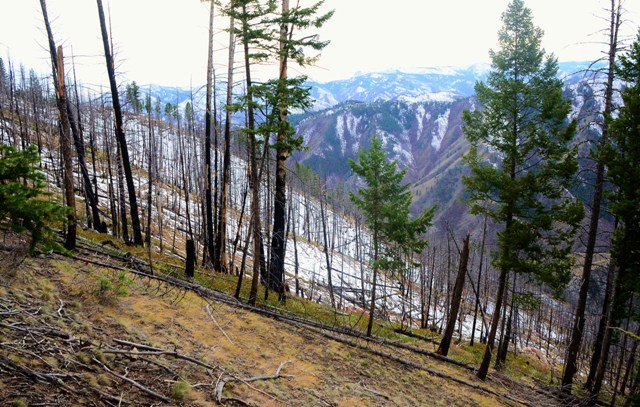
We put on significant mileage by mid afternoon. Big Creek snakes endlessly through rugged mountain terrain. Multicolored igneous rock crops out frequently along its steep canyon sidewalls. But many slopes are grass and pine covered. Climate has turned much drier now that we are down in elevation from our starting point yesterday. More grass. Fewer trees. Some of the tree patches are scorched from past wildfires. Wildfire clearly is playing a major role in the distribution of forested patches on the mountain slopes.

Skyla finds some bones during a rest. They are an elk radius and ulna still articulated. She plays with them like dolls.
Time to get back in the pack. After 22 state Remote Spots accomplished, Skyla is a pro at riding in a backpack. And she likes it.
We pass through the Coxy Creek fire that burned about 2 weeks ago. It was just extinguished by heavy rain associated with Winter Storm Atlas. The foot trail actually became a fire break. When the fire from the north hit the trail, it simply ran out of fuel at the trail and went out. It must have been either backing toward the trail or burning slowly without wind. Kevin gets excited at the sight of a burn, being a smoke jumper, of course, and he always speaks a wealth of information about burn mechanics and fire ecology.
Big Creek continues to gain volume and climate gets ever drier. We fade as little dots on the expansive landscape. The only thing that detracts from this scene is the contrail over the far mountain. While conceiving Project Remote, we felt that it would be impossible to quantify where airplanes fly in a fluid atmosphere with no structural boundaries. We now know that airplanes do roughly stick to flyways designated by the FAA. Seeing regular jet traffic overhead while being in remote wilderness areas detracts from our wilderness experience. Nonetheless, we still adhere to our definition of remoteness, which is quantified primarily in terms of distance from a road.
There…that’s better. This may be on our top ten list of “most beautiful rivers” we’ve ever seen. Since winter storm Atlas, fantastic dry, blue-sky weather has been the norm. Also, and more importantly, we have lost more of the snow that recently blanketed the hill tops. My un-ease about whether we will be successful is relaxing a as I calculate that our chances of accomplishing the Idaho Remote Spot increases dramatically as snow melts…I just hope snow is melting sufficiently at 7500 feet elevation where the remote spot resides.
Second camp of the expedition. We covered approximately 10 miles today.
Day 3 takes us all the way to the mouth of Cave Creek, which is within striking distance of the Idaho Remote Spot. When we get close to a Remote Spot that requires multi-day wilderness travel, we typically set up a base camp so we can stow gear, drop weight, and have camp already set up for the next night after the documentation is over. Plus, we usually are beat and need some time for rejuvenation. We stick to what works in this remote spotting operation…
Some daddy/daughter time doesn’t hurt, either…She helps gather firewood.
A little rest and rejuvenation goes a long way! It’s morning of Day 4 and the fantastic weather holds on for us…for now…Who’s ready to Go Remote?
Kevin’s already shaking off the frost.
Day 4. Time to Go Remote in Idaho. We set out up Cave Creek, then up, up, up the ridge on the east side of the creek. The remote spot is 2600 feet higher than base camp just 3.5 linear miles away-mostly off trail. This ain’t like Florida, our flat home state. But fortunately, most of the vegetation is low bunch grass and easy to navigate through. At least in the beginning.
Dadoo takes on the Skyla backpack on Remote Spot days to give Momma a break. It’s also a break for me since it is substantially lighter than my gear-hauling mega-pack. Will I ever get to go backpacking lightly? Who cares…it’s much better to go with your children than without.
What a view atop the ridge down onto Cave Creek Canyon. We are about half way to the Remote Spot now from our basecamp, which is at the bottom of the canyon…
Once up high, we navigate along the ridge top toward the Remote Spot. Often there are game trails to follow. Generations of animals have walked these hills for eons, and they have selected the best routes. We follow.

Snow cover increases as we ascend. North-facing slopes turn white. I hope the Remote Spot isn’t buried. Time already is running short. This always takes longer than we anticipate. It’s just not that easy to navigate mountain wilderness while trying to adhere to a time schedule. Especially while towing your four-year-old. Even if she is the best wilderness traveling four-year-older we’ve ever seen.

The second half of today’s Remote Spot attempt takes much longer than the first, and vegetation increases with elevation. The west side of the ridge is recently burned within the last few years. This makes for some rough walking both on slope and through fallen tree snags. Clouds build in from the northwest rather rapidly. I guess this blue sky weather can’t hold forever. Squirrely mountain winds pick up, temperature decreases, and time runs thin…
Like in Montana, we set a time cutoff for this remote spot attempt to give ourselves plenty of daylight to navigate back to camp before nightfall…That time is 3pm. Now it’s 3:30, and the brushy burn tries to stiff-arm our attempt. I start saying a few of what Skyla calls, dadoo words, both to myself and aloud as my frustration builds. We are soooo close that we simply can’t turn back now. How could 3.5 miles take so damn long to navigate? Well, throw in snow, brush, no-trail, heavy pack weight, and steep elevation gains-and there’s my answer…
But we are going to make it. We have to.

And here it is-The remotest location in all of Idaho. It’s almost an anticlimax. Almost…
We can’t contain our elation for long!

Below is the view southward off the Idaho Remote Spot in the center of the Frank Church-River of No Return Wilderness.
We work ridiculously fast to get our documentary work done almost without a word spoken. Everyone knows we must return the entire distance to camp afterwards with daylight running short…When done, we deliberate on which route to take back. Go the way we came or gamble by dropping straight down to upper Cave Creek to a known trail…There is a chance that the canyon side could become too steep for us to scramble down. If so, we’d be stranded for the night on a steep slope having to bed down with bare minimum sleep gear, and possibly during a storm which approaches. All this with the most precious cargo parents can have…We decide to gamble, believing that we have read the topo map properly, having spotted a route down, albeit a steep one…Gravity could only help. We stumble-jog downward on sore feet and knees. Amid the pain, we at least make great time.

It’s 48 degrees out and windy. The last thing in the world we expect to find on the ground is a snake! But we did-We score big as we encounter the first rubber boa (Charina botae) we’ve ever seen in the wild just laying on the ground in a small sun patch.

I’m giddy like a child, no doubt high on having just accomplished documentation of the Idaho Remote Spot and now this! Plus, we have spotted a passable route down and are making awesome time back to camp with gravity working for us. “Let me see, Dadoo!” says an enthusiastic Skyla…I tell her all I can about the snake while trying to catch breath. We all delight in the experience. This is probably the remotest rubber boa in all of Idaho…
The rest of the 2-hour downhill speed-hike back to base camp is a tiresome and beautiful blur. We arrived 30 minutes past dark. There were plenty of chores like dinner making, water pumping, and replacement of wet, cold clothing with dry and warm layers. Getting Skyla ready for bed…At least no precipitation had fallen yet.
In the middle of the night, something wildly wonderful yet frightening happens…I awaken out of a dead sleep to the howling of a wolf pack seemingly all around us. We adults are all awake…Skyla still sleeps. Rebecca and I deliberate on whether to awaken Skyla out of deep sleep so she could experience it. It started off as one individual howling, then several others chimed in…After a solid minute, the sound gets so close that I reach for weapons. My heart races, no doubt genetically tuned to fear such wild sounds of apex predators positioning all around…I didn’t know which would be better-stay huddled in the tent like sitting ducks, or step outside and risk getting separated from the girls. Not ever having been surrounded by howling wolves, I wasn’t sure what to do. Then suddenly-the deafening howling chorus stops. Remote silence again. No sound whatsoever. Were they still there?
I stayed awake for a while, not able to sleep after such a cage-rattling, imagining that the powerful pack predators had notified us that we were in their territory, perhaps sending us a warning…We are unaware of any recent human deaths caused by wolves in North America…But the potential certainly is there. Having our little girl out there in the remotest location in all of Idaho-just us and a wolf pack at 2 a.m. in the middle of the Frank, well, had me stirred up just a little. But the encounter plays out perfectly in the end. Wolves howl all around us at night in the middle of the wilderness without any harm to us or them.
……………….
We spent the next two days putting on big miles to try to make it out of there in less time than we had come in (11.2 miles on Day 5, 10.2 miles on Day 6). The boys’ packs lighten up somewhat, although the Skyla backpack stays the same throughout…The rain finally came at Day 5’s end…(end of Idaho journal coming soon!)


Project Remote Fundraiser: After reading this website, you might be surprised at just how hard it is to get away from a road or a town nowadays in the majority of America. The importance of documenting and protecting remaining public roadless areas from further roads development instantly becomes clear. Project Remote is now well over half-way done! Our goal is to raise enough funding simply to offset the cost of traveling frugally state by state, completing the documentary field work, and maintaining this website. If you like what we do, please Click here to make a donation to support Project Remote today. Thank you so very much for helping us to document and preserve Remote America…
-Remote Footprints

